
Thank you for supporting this site ❤️
Make a donation
Make a donation
Gear up for your next adventure:
As an Amazon Associate, this site earns from qualifying purchases at no extra cost to you.
Cerro Morocho Chico topographic map
Click on the map to display elevation.
Thank you for supporting this site ❤️
Make a donation
Make a donation
Gear up for your next adventure:
As an Amazon Associate, this site earns from qualifying purchases at no extra cost to you.
About this map
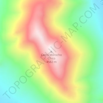
Name: Cerro Morocho Chico topographic map, elevation, terrain.
Average elevation: 13,914 ft
Minimum elevation: 12,877 ft
Maximum elevation: 15,098 ft
Thank you for supporting this site ❤️
Make a donation
Make a donation
Gear up for your next adventure:
As an Amazon Associate, this site earns from qualifying purchases at no extra cost to you.
Other topographic maps
Click on a map to view its topography, its elevation and its terrain.
Salinas Grandes
Hanno un'estensione di 600 km2 e si trovano a una altitudine media di 3450 m slm.
Average elevation: 994 ft