Geolocate

Kumberg topographic map

Click on the map to display elevation.

About this map

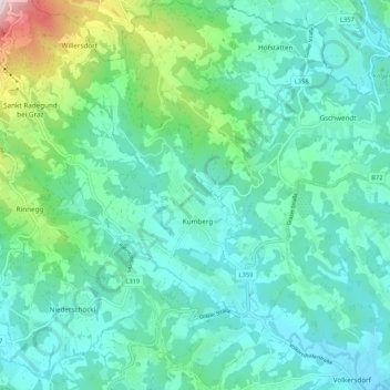
Name: Kumberg topographic map, elevation, terrain.

Location: Kumberg, Bezirk Graz-Umgebung, Styria, 8062, Austria (47.12888 15.50123 47.20062 15.59051)

Average elevation: 1,808 ft

Minimum elevation: 1,355 ft

Maximum elevation: 3,671 ft

Other topographic maps

Click on a map to view its topography, its elevation and its terrain.

Schöckl

Austria > Styria > Bezirk Graz-Umgebung > St. Radegund

Average elevation: 3,727 ft

Thondorf

Austria > Styria > Bezirk Graz-Umgebung

Average elevation: 1,106 ft

Dornegg

Austria > Styria > Bezirk Graz-Umgebung > St. Marein bei Graz

Average elevation: 1,437 ft

Gear up for your next adventure:

🏥Hiking First Aid Kits - Comprehensive medical kits for remote trail injuries
🌐World Map Poster - Decorative world maps with topographic info
🎒Hydration Pack - Hands‑free water reservoir for long hikes
🛡️Insect Repellent - Protection against bugs during outdoor activities
🧦Merino Wool Socks - Moisture-wicking, blister-preventing socks for long treks

As an Amazon Associate, this site earns from qualifying purchases at no extra cost to you.