
Make a donation
Gear up for your next adventure:
As an Amazon Associate, this site earns from qualifying purchases at no extra cost to you.
Brdy topographic map
Click on the map to display elevation.
Make a donation
Gear up for your next adventure:
As an Amazon Associate, this site earns from qualifying purchases at no extra cost to you.
Brdy
Brdy is a range of hills in the Czech Republic, forming a long massif stretching for c. 60 km southwest from Prague. The northern section of the Brdy is called "Hřebeny" and features one narrow ridge (highest elevation Písek - 690 m). The main Brdy range starts south of the Litavka river gorge and consists of several major elevations connected into one plateau, the highest peaks among them being Tok (864 m), Praha (862 m) or Třemšín (827 m). Most of the Brdy is covered by forest, and it is one of the largest contiguously forested areas in the interior of the country. Large sections of the massif are designated as a restricted military area and closed to the public. The Brdy military area has been a source of controversy for several decades.
Make a donation
Gear up for your next adventure:
As an Amazon Associate, this site earns from qualifying purchases at no extra cost to you.
About this map
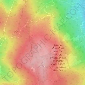
Name: Brdy topographic map, elevation, terrain.
Location: Brdy, Obecnice, okres Příbram, Central Bohemia, Czechia (49.71071 13.87673 49.71081 13.87683)
Average elevation: 2,566 ft
Minimum elevation: 2,119 ft
Maximum elevation: 2,844 ft
Make a donation
Gear up for your next adventure:
As an Amazon Associate, this site earns from qualifying purchases at no extra cost to you.