
Pedra Azul topographic map
Click on the map to display elevation.
Pedra Azul
The city belongs to the mesoregion of Jequitinhonha and to the microregion of Pedra Azul. The elevation of the municipal seat is 617 meters. It became a municipality in 1911. This municipality is located 16 km. to the east of the important BR-116 highway, which links Rio de Janeiro to Salvador. The boundary with the state of Bahia is 49 km. to the northeast.
About this map
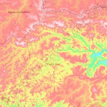
Name: Pedra Azul topographic map, elevation, terrain.
Average elevation: 2,536 ft
Minimum elevation: 1,371 ft
Maximum elevation: 3,504 ft