
Make a donation
Gear up for your next adventure:
As an Amazon Associate, this site earns from qualifying purchases at no extra cost to you.
Wilson Reservoir topographic map
Click on the map to display elevation.
Make a donation
Gear up for your next adventure:
As an Amazon Associate, this site earns from qualifying purchases at no extra cost to you.
Wilson Reservoir
Wilson Lake is located at 38°56′25″N 98°33′24″W / 38.94028°N 98.55667°W / 38.94028; -98.55667 (38.9401464, -98.5567638) at an elevation of 1,516 feet (462 m). It lies in north-central Kansas in the Smoky Hills region of the Great Plains. Most of Wilson Lake lies in Russell County with a small portion of its southeastern arm extending into Lincoln County.
Make a donation
Gear up for your next adventure:
As an Amazon Associate, this site earns from qualifying purchases at no extra cost to you.
About this map
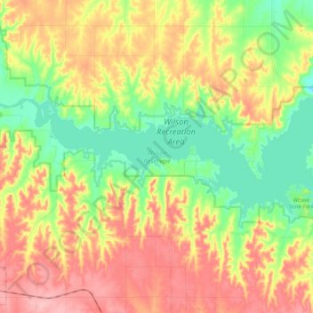
Name: Wilson Reservoir topographic map, elevation, terrain.
Location: Wilson Reservoir, Russell County, Kansas, United States (38.90773 -98.67043 38.96942 -98.47646)
Average elevation: 1,667 ft
Minimum elevation: 1,473 ft
Maximum elevation: 1,883 ft
Russell County trails, hiking, mountain biking, running and outdoor activities
Make a donation
Gear up for your next adventure:
As an Amazon Associate, this site earns from qualifying purchases at no extra cost to you.