
Thank you for supporting this site ❤️
Make a donation
Make a donation
Gear up for your next adventure:
As an Amazon Associate, this site earns from qualifying purchases at no extra cost to you.
Antouilleux topographic map
Click on the map to display elevation.
Thank you for supporting this site ❤️
Make a donation
Make a donation
Gear up for your next adventure:
As an Amazon Associate, this site earns from qualifying purchases at no extra cost to you.
About this map
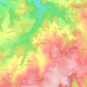
Name: Antouilleux topographic map, elevation, terrain.
Average elevation: 2,297 ft
Minimum elevation: 1,795 ft
Maximum elevation: 2,618 ft
Thank you for supporting this site ❤️
Make a donation
Make a donation
Gear up for your next adventure:
As an Amazon Associate, this site earns from qualifying purchases at no extra cost to you.
Other topographic maps
Click on a map to view its topography, its elevation and its terrain.
42240
France > Auvergne-Rhône-Alpes > Loire > Saint-Maurice-en-Gourgois > La Goutte
Average elevation: 1,972 ft