
Thank you for supporting this site ❤️
Make a donation
Make a donation
Gear up for your next adventure:
As an Amazon Associate, this site earns from qualifying purchases at no extra cost to you.
Phú Mỹ Town topographic map
Click on the map to display elevation.
Thank you for supporting this site ❤️
Make a donation
Make a donation
Gear up for your next adventure:
As an Amazon Associate, this site earns from qualifying purchases at no extra cost to you.
About this map
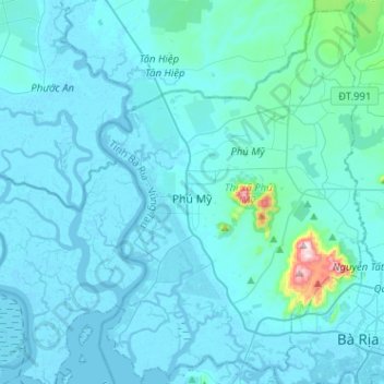
Name: Phú Mỹ Town topographic map, elevation, terrain.
Location: Phú Mỹ Town, Bà Rịa - Vũng Tàu Province, 78706, Vietnam (10.46597 106.99683 10.71684 107.17434)
Average elevation: 92 ft
Minimum elevation: -13 ft
Maximum elevation: 1,634 ft
Thank you for supporting this site ❤️
Make a donation
Make a donation
Gear up for your next adventure:
As an Amazon Associate, this site earns from qualifying purchases at no extra cost to you.
Other topographic maps
Click on a map to view its topography, its elevation and its terrain.
Hồ Tràm
Vietnam > Bà Rịa - Vũng Tàu Province > Xuyên Mộc District > Phuoc Thuan Commune
Average elevation: 30 ft