
Thank you for supporting this site ❤️
Make a donation
Make a donation
Gear up for your next adventure:
As an Amazon Associate, this site earns from qualifying purchases at no extra cost to you.
North Waltham topographic map
Click on the map to display elevation.
Thank you for supporting this site ❤️
Make a donation
Make a donation
Gear up for your next adventure:
As an Amazon Associate, this site earns from qualifying purchases at no extra cost to you.
About this map
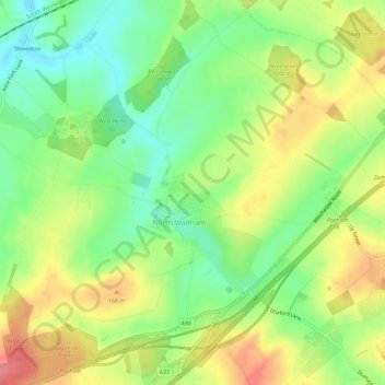
Name: North Waltham topographic map, elevation, terrain.
Average elevation: 456 ft
Minimum elevation: 331 ft
Maximum elevation: 607 ft
Thank you for supporting this site ❤️
Make a donation
Make a donation
Gear up for your next adventure:
As an Amazon Associate, this site earns from qualifying purchases at no extra cost to you.
Other topographic maps
Click on a map to view its topography, its elevation and its terrain.
Cocksford Firs East
United Kingdom > England > Hampshire > Basingstoke and Deane > Steventon
Average elevation: 502 ft
Sherborne St John
United Kingdom > England > Hampshire > Basingstoke and Deane
Average elevation: 302 ft