
Thank you for supporting this site ❤️
Make a donation
Make a donation
Gear up for your next adventure:
As an Amazon Associate, this site earns from qualifying purchases at no extra cost to you.
Huanfeng topographic map
Click on the map to display elevation.
Thank you for supporting this site ❤️
Make a donation
Make a donation
Gear up for your next adventure:
As an Amazon Associate, this site earns from qualifying purchases at no extra cost to you.
About this map
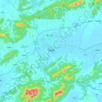
Name: Huanfeng topographic map, elevation, terrain.
Location: Huanfeng, Hanshan County, Ma'anshan, Anhui, 238100, China (31.61612 118.01223 31.80101 118.21772)
Average elevation: 171 ft
Minimum elevation: 16 ft
Maximum elevation: 1,509 ft
Thank you for supporting this site ❤️
Make a donation
Make a donation
Gear up for your next adventure:
As an Amazon Associate, this site earns from qualifying purchases at no extra cost to you.