Geolocate

Bobingen topographic map

Click on the map to display elevation.

About this map

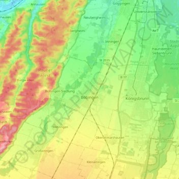
Name: Bobingen topographic map, elevation, terrain.

Location: Bobingen, Augsburg (district), Bavaria, 86399, Germany (48.24160 10.67180 48.30760 10.87587)

Average elevation: 1,722 ft

Minimum elevation: 1,545 ft

Maximum elevation: 1,965 ft

Other topographic maps

Click on a map to view its topography, its elevation and its terrain.

Leuthau

Germany > Bavaria > Augsburg (district) > Schwabmünchen > Klimmach

Average elevation: 1,893 ft

Erlingen

Germany > Bavaria > Augsburg (district) > Meitingen

Average elevation: 1,427 ft

Westendorf

Germany > Bavaria > Augsburg (district) > Westendorf > Westendorf

Average elevation: 1,430 ft

Gear up for your next adventure:

🔥Plasma Lighters - Windproof lighters that work in any weather condition
🍳Camping Cook Set - Complete cookware for outdoor meals
🌡️Portable Weather Meter - Track weather conditions on the trail
🧴Hand Sanitizer - Keep hands clean while hiking
☀️Outdoor Sunscreen - High protection sunscreen for outdoor activities

As an Amazon Associate, this site earns from qualifying purchases at no extra cost to you.