
Make a donation
Gear up for your next adventure:
As an Amazon Associate, this site earns from qualifying purchases at no extra cost to you.
Langenrehm topographic map
Click on the map to display elevation.
Make a donation
Gear up for your next adventure:
As an Amazon Associate, this site earns from qualifying purchases at no extra cost to you.
About this map
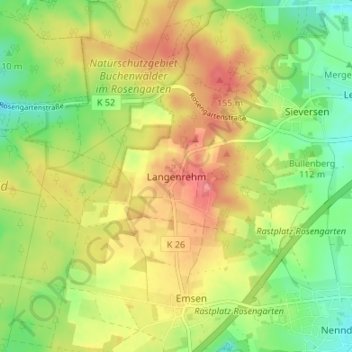
Name: Langenrehm topographic map, elevation, terrain.
Location: Langenrehm, Rosengarten, Harburg, Lower Saxony, Germany (53.37785 9.84007 53.41785 9.88007)
Average elevation: 377 ft
Minimum elevation: 249 ft
Maximum elevation: 512 ft
Make a donation
Gear up for your next adventure:
As an Amazon Associate, this site earns from qualifying purchases at no extra cost to you.
Other topographic maps
Click on a map to view its topography, its elevation and its terrain.
Neu Wulmstorf
Germany > Lower Saxony > Harburg
Further up, the villages Wulmstorf, Daerstorf, Schwiederstorf, Rade are marking the highest elevations of Neu Wulmstorf on the western outskirts of the Harburg Hills.
Average elevation: 144 ft
Make a donation
Gear up for your next adventure:
As an Amazon Associate, this site earns from qualifying purchases at no extra cost to you.
Make a donation
Gear up for your next adventure:
As an Amazon Associate, this site earns from qualifying purchases at no extra cost to you.
Make a donation
Gear up for your next adventure:
As an Amazon Associate, this site earns from qualifying purchases at no extra cost to you.