Geolocate

Dispur topographic map

Click on the map to display elevation.

About this map
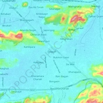
Name: Dispur topographic map, elevation, terrain.

Location: Dispur, Kamrup Metropolitan, Assam, 781005, India (26.10094 91.75103 26.18094 91.83103)

Average elevation: 256 ft

Minimum elevation: 157 ft

Maximum elevation: 896 ft

Gear up for your next adventure:

🪵Folding Camp Saw - Compact saw for wood and campsite work
🧢Outdoor Hiking Hat - Sun protection hat for outdoor explorers
⛑️Personal Locator Beacon - Safety beacon for emergencies
🔪Outdoor Multitools - Essential survival tools for gear repair and field use
🎒Outdoor Daypacks - Lightweight backpacks designed for carrying maps and essential gear

As an Amazon Associate, this site earns from qualifying purchases at no extra cost to you.