Geolocate

Guapi topographic map

Click on the map to display elevation.

About this map

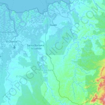
Name: Guapi topographic map, elevation, terrain.

Location: Guapi, Pacífico, Cauca, RAP Pacífico, Colombia (2.13357 -77.92802 2.70564 -77.37515)

Average elevation: 190 ft

Minimum elevation: -13 ft

Maximum elevation: 3,474 ft

Other topographic maps

Click on a map to view its topography, its elevation and its terrain.

Monteredondo

Colombia > Cauca > El Tambo

Average elevation: 5,515 ft

Guanacas

Colombia > Cauca > Inzá

Average elevation: 6,660 ft

La Marquesa

Colombia > Cauca > Silvia

Average elevation: 11,115 ft

Coconuco

Colombia > Cauca > Puracé

Average elevation: 8,927 ft

Las Botas

Colombia > Cauca > El Tambo

Average elevation: 5,673 ft

Loma Grande

Colombia > Cauca > San Sebastián

Average elevation: 6,988 ft

Chamon

Colombia > Cauca > Guapi

Average elevation: 7 ft

Chisquio

Colombia > Cauca > El Tambo

Average elevation: 5,814 ft

Lopez

Colombia > Cauca > Toribío

Average elevation: 10,128 ft

Puracé

Colombia > Cauca > Puracé > Puracé

Average elevation: 8,786 ft

Gear up for your next adventure:

🌧️Backpack Rain Cover - Keep gear dry in wet weather
🦺Reflective Outdoor Gear - Safety gear for low‑light conditions
🦶Carbon Trekking Poles - Reduce knee impact on steep descents with ultra-light poles
🧤Tactile Hiking Gloves - Keep hands warm while operating GPS and smartphone screens
🩳Quick‑Dry Hiking Shorts - Comfortable and quick‑dry shorts for summer hiking

As an Amazon Associate, this site earns from qualifying purchases at no extra cost to you.