
Thank you for supporting this site ❤️
Make a donation
Make a donation
Gear up for your next adventure:
As an Amazon Associate, this site earns from qualifying purchases at no extra cost to you.
Trenton topographic map
Click on the map to display elevation.
Thank you for supporting this site ❤️
Make a donation
Make a donation
Gear up for your next adventure:
As an Amazon Associate, this site earns from qualifying purchases at no extra cost to you.
About this map
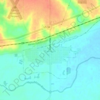
Name: Trenton topographic map, elevation, terrain.
Location: Trenton, Hitchcock County, Nebraska, 69044, United States (40.16836 -101.02273 40.18387 -101.00348)
Average elevation: 2,710 ft
Minimum elevation: 2,657 ft
Maximum elevation: 2,805 ft
Hitchcock County trails, hiking, mountain biking, running and outdoor activities
Thank you for supporting this site ❤️
Make a donation
Make a donation
Gear up for your next adventure:
As an Amazon Associate, this site earns from qualifying purchases at no extra cost to you.