
Thank you for supporting this site ❤️
Make a donation
Make a donation
Gear up for your next adventure:
As an Amazon Associate, this site earns from qualifying purchases at no extra cost to you.
Riva di Solto topographic map
Click on the map to display elevation.
Thank you for supporting this site ❤️
Make a donation
Make a donation
Gear up for your next adventure:
As an Amazon Associate, this site earns from qualifying purchases at no extra cost to you.
About this map
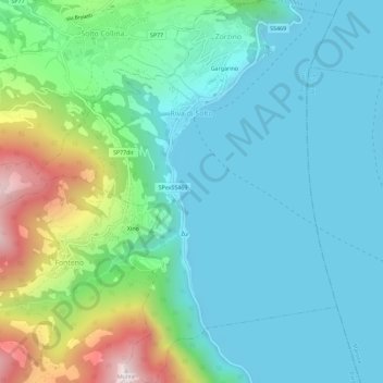
Name: Riva di Solto topographic map, elevation, terrain.
Location: Riva di Solto, Bergamo, Lombardy, 24060, Italy (45.74521 10.00522 45.78523 10.06036)
Average elevation: 1,266 ft
Minimum elevation: 574 ft
Maximum elevation: 3,576 ft
Thank you for supporting this site ❤️
Make a donation
Make a donation
Gear up for your next adventure:
As an Amazon Associate, this site earns from qualifying purchases at no extra cost to you.