Geolocate

Rore topographic map

Click on the map to display elevation.

About this map

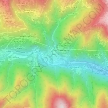
Name: Rore topographic map, elevation, terrain.

Location: Rore, Sampeyre, Cuneo, Piemonte, Italia (44.55660 7.20693 44.59660 7.24693)

Average elevation: 3,839 ft

Minimum elevation: 2,556 ft

Maximum elevation: 5,623 ft

Other topographic maps

Click on a map to view its topography, its elevation and its terrain.

Lago di Luca

Italia > Piemonte > Cuneo > Sampeyre

Average elevation: 7,684 ft

Gear up for your next adventure:

🪵Folding Camp Saw - Compact saw for wood and campsite work
🌲Outdoor Survival Books - Best books on survival skills
🌐World Map Poster - Decorative world maps with topographic info
Backpacking Tent - Lightweight and durable tent for multi‑day hikes
🪑Ultralight Camp Chairs - Portable seating for resting after a long day of mapping

As an Amazon Associate, this site earns from qualifying purchases at no extra cost to you.