Geolocate

Clachan topographic map

Click on the map to display elevation.

About this map

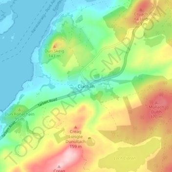
Name: Clachan topographic map, elevation, terrain.

Location: Clachan, Argyll and Bute, Scotland, PA29 6YP, United Kingdom (55.72678 -5.58178 55.76678 -5.54178)

Average elevation: 246 ft

Minimum elevation: -3 ft

Maximum elevation: 650 ft

Other topographic maps

Click on a map to view its topography, its elevation and its terrain.

Tarbert

United Kingdom > Scotland > Argyll and Bute

Average elevation: 226 ft

Easdale

United Kingdom > Scotland > Argyll and Bute > Easdale

Average elevation: 26 ft

Torsa

United Kingdom > Scotland > Argyll and Bute > Cuan > Silver Moon

Average elevation: 39 ft

Texa

United Kingdom > Scotland > Argyll and Bute

Average elevation: 3 ft

Bute

United Kingdom > Scotland > Argyll and Bute > Townhead

Average elevation: 135 ft

Scarba

United Kingdom > Scotland > Argyll and Bute

Average elevation: 299 ft

Coll

United Kingdom > Scotland > Argyll and Bute > Arinagour

Average elevation: 23 ft

Ardrishaig

United Kingdom > Scotland > Argyll and Bute

Average elevation: 217 ft

Gear up for your next adventure:

🎒Waterproof Dry Bags - Keep your electronics and maps dry inside your pack
🌲Outdoor Survival Books - Best books on survival skills
🔥Plasma Lighters - Windproof lighters that work in any weather condition
🏫Relief Map Kits - Hands-on tools for teaching landforms and elevation
🛡️Bear Spray Outdoor - Protection in bear country hikes

As an Amazon Associate, this site earns from qualifying purchases at no extra cost to you.