Geolocate

Texa topographic map

Click on the map to display elevation.

About this map

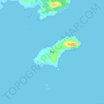
Name: Texa topographic map, elevation, terrain.

Location: Texa, Argyll and Bute, Scotland, United Kingdom (55.61286 -6.15424 55.62147 -6.13178)

Average elevation: 3 ft

Minimum elevation: -3 ft

Maximum elevation: 135 ft

Other topographic maps

Click on a map to view its topography, its elevation and its terrain.

Rhu

United Kingdom > Scotland > Argyll and Bute

Average elevation: 220 ft

Rothesay

United Kingdom > Scotland > Argyll and Bute

Average elevation: 125 ft

Tarbert

United Kingdom > Scotland > Argyll and Bute

Average elevation: 226 ft

Easdale

United Kingdom > Scotland > Argyll and Bute > Easdale

Average elevation: 26 ft

Campbeltown

United Kingdom > Scotland > Argyll and Bute

Average elevation: 276 ft

Lochgilphead

United Kingdom > Scotland > Argyll and Bute

Average elevation: 335 ft

Bute

United Kingdom > Scotland > Argyll and Bute > Townhead

Average elevation: 135 ft

Salen

United Kingdom > Scotland > Argyll and Bute

Average elevation: 177 ft

Clachan

United Kingdom > Scotland > Argyll and Bute

Average elevation: 246 ft

Scarba

United Kingdom > Scotland > Argyll and Bute

Average elevation: 299 ft

Oban

United Kingdom > Scotland > Argyll and Bute

Average elevation: 154 ft

Arrochar

United Kingdom > Scotland > Argyll and Bute

Average elevation: 712 ft

Coll

United Kingdom > Scotland > Argyll and Bute > Arinagour

Average elevation: 23 ft

Ardlui

United Kingdom > Scotland > Argyll and Bute > Ardlui

Average elevation: 801 ft

Gear up for your next adventure:

📷Action Cameras - Rugged cameras to document your journeys across rugged terrain
🪶Thermal Camp Blanket - Extra warmth for cold nights
🌲Outdoor Survival Books - Best books on survival skills
🛡️Insect Repellent - Protection against bugs during outdoor activities
🪶Camping Sleeping Pad - Comfortable sleeping pad for backpacking

As an Amazon Associate, this site earns from qualifying purchases at no extra cost to you.