Geolocate

Myren topographic map

Click on the map to display elevation.

About this map

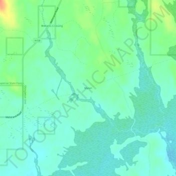
Name: Myren topographic map, elevation, terrain.

Location: Myren, Munising Township, Alger County, Michigan, United States (46.40607 -86.44738 46.44607 -86.40738)

Average elevation: 889 ft

Minimum elevation: 850 ft

Maximum elevation: 994 ft

Alger County trails, hiking, mountain biking, running and outdoor activities

Other topographic maps

Click on a map to view its topography, its elevation and its terrain.

Au Train Township

United States > Michigan > Alger County

Average elevation: 804 ft

Chatham

United States > Michigan > Alger County

Average elevation: 873 ft

Rock River

United States > Michigan > Alger County > Onota Township

Average elevation: 722 ft

Gear up for your next adventure:

🧴Hand Sanitizer - Keep hands clean while hiking
🧯Portable Fire Pit - Compact fire pit for camping spots
🎒Day Hiking Backpack - Lightweight backpack perfect for day trips and outdoor adventures
Solar GPS Watches - Advanced multisport watches with built-in topographic maps
🎒Waterproof Dry Bags - Keep your electronics and maps dry inside your pack

As an Amazon Associate, this site earns from qualifying purchases at no extra cost to you.