
Cornwall topographic map
Click on the map to display elevation.
About this map
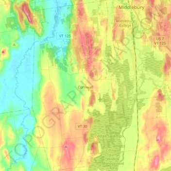
Name: Cornwall topographic map, elevation, terrain.
Location: Cornwall, Addison County, Vermont, United States (43.90481 -73.25926 44.01889 -73.16393)
Average elevation: 341 ft
Minimum elevation: 131 ft
Maximum elevation: 623 ft
Addison County trails, hiking, mountain biking, running and outdoor activities
Other topographic maps
Click on a map to view its topography, its elevation and its terrain.
Kingsland Bay
United States > Vermont > Addison County > Ferrisburgh > Ecole Champlain
Average elevation: 105 ft
Abbey Pond Cascades (lower)
United States > Vermont > Addison County > Middlebury
Average elevation: 1,001 ft
Lake Dunmore
United States > Vermont > Addison County > Salisbury > Lake Dunmore
Average elevation: 630 ft