Geolocate

Bellevue topographic map

Click on the map to display elevation.

About this map

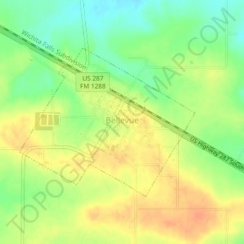
Name: Bellevue topographic map, elevation, terrain.

Location: Bellevue, Clay County, Texas, United States (33.62568 -98.02804 33.64208 -98.00467)

Average elevation: 1,027 ft

Minimum elevation: 958 ft

Maximum elevation: 1,083 ft

Clay County trails, hiking, mountain biking, running and outdoor activities

Other topographic maps

Click on a map to view its topography, its elevation and its terrain.

Charlie

United States > Texas > Clay County > Charlie

Average elevation: 951 ft

Henrietta

United States > Texas > Clay County > Henrietta > Henrietta

Average elevation: 892 ft

Gear up for your next adventure:

🪶Multi‑Purpose Knife - Useful blade for camp and trail
🧼Biodegradable Camping Soap - Eco‑friendly soap for outdoor hygiene
Backpacking Tents - Weight-optimized shelters for multi-day topographic surveys
🧺Microfiber Travel Towels - Compact and fast-drying towels for trail use
🎒Trekking Poles - Sturdy poles for balance and stability on rough terrain

As an Amazon Associate, this site earns from qualifying purchases at no extra cost to you.