Geolocate

Dong-gu topographic map

Click on the map to display elevation.

About this map

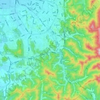
Name: Dong-gu topographic map, elevation, terrain.

Location: Dong-gu, Gwangju, South Korea (35.07233 126.90721 35.16546 127.00425)

Average elevation: 502 ft

Minimum elevation: 75 ft

Maximum elevation: 1,834 ft

Gear up for your next adventure:

🪵Folding Camp Saw - Compact saw for wood and campsite work
🌡️Portable Weather Meter - Track weather conditions on the trail
🧭Pro Hiking Compasses - High-accuracy liquid-filled compasses for topographic orientation
🪶Camp Gear Gift Set - Perfect gift bundle for outdoor fans
🏔️Mountain Trail Maps - High‑detail maps for popular peaks

As an Amazon Associate, this site earns from qualifying purchases at no extra cost to you.