Geolocate

Equality topographic map

Click on the map to display elevation.

About this map

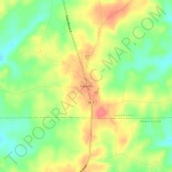
Name: Equality topographic map, elevation, terrain.

Location: Equality, Coosa County, Alabama, 36026, United States (32.74207 -86.12191 32.78207 -86.08191)

Average elevation: 663 ft

Minimum elevation: 554 ft

Maximum elevation: 774 ft

Coosa County trails, hiking, mountain biking, running and outdoor activities

Other topographic maps

Click on a map to view its topography, its elevation and its terrain.

Goodwater

United States > Alabama > Coosa County

Average elevation: 823 ft

Kellyton

United States > Alabama > Coosa County

Average elevation: 738 ft

Rockford

United States > Alabama > Coosa County

Average elevation: 725 ft

Gear up for your next adventure:

📦Dry Bags Set - Waterproof storage for electronics and clothes
🔭Telescopic Hiking Pole - Adjustable pole for hiking stability
🚪Portable Camp Chair - Foldable chair for comfort at camp
🌎3D Topographic Globes - Raised relief globes for a tactile understanding of geography
🧯Portable Fire Pit - Compact fire pit for camping spots

As an Amazon Associate, this site earns from qualifying purchases at no extra cost to you.