Geolocate

Lake Nebagamon topographic map

Click on the map to display elevation.

About this map

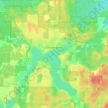
Name: Lake Nebagamon topographic map, elevation, terrain.

Location: Lake Nebagamon, Douglas County, Wisconsin, 54849, United States (46.47453 -91.73914 46.54647 -91.65821)

Average elevation: 1,152 ft

Minimum elevation: 1,070 ft

Maximum elevation: 1,250 ft

Douglas County trails, hiking, mountain biking, running and outdoor activities

Other topographic maps

Click on a map to view its topography, its elevation and its terrain.

Dairyland

United States > Wisconsin > Douglas County

Average elevation: 1,112 ft

Winneboujou

United States > Wisconsin > Douglas County > Town of Brule

Average elevation: 1,093 ft

Hawthorne

United States > Wisconsin > Douglas County

Average elevation: 1,171 ft

South Range

United States > Wisconsin > Douglas County

Average elevation: 778 ft

Bennett

United States > Wisconsin > Douglas County

Average elevation: 1,207 ft

Foxboro

United States > Wisconsin > Douglas County

Average elevation: 909 ft

Gear up for your next adventure:

🪶Paracord Bracelet - Survival bracelet with built‑in tools
🏔️Mountain Trail Maps - High‑detail maps for popular peaks
🎁Geography Themed Gifts - Unique gift ideas for map lovers and geography enthusiasts
🔋Solar Power Banks - Keep your GPS and phone charged in remote wilderness areas
🏥Hiking First Aid Kits - Comprehensive medical kits for remote trail injuries

As an Amazon Associate, this site earns from qualifying purchases at no extra cost to you.