
Make a donation
Gear up for your next adventure:
As an Amazon Associate, this site earns from qualifying purchases at no extra cost to you.
South Georgia topographic map
Click on the map to display elevation.
Make a donation
Gear up for your next adventure:
As an Amazon Associate, this site earns from qualifying purchases at no extra cost to you.
South Georgia
The island's topography includes a stepped sequence of flat surfaces interpreted as wave-cut platforms formed when sea level was higher relative to the island. At sea level strandflats have been described.
Make a donation
Gear up for your next adventure:
As an Amazon Associate, this site earns from qualifying purchases at no extra cost to you.
About this map
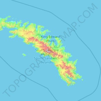
Name: South Georgia topographic map, elevation, terrain.
Average elevation: 285 ft
Minimum elevation: -3 ft
Maximum elevation: 9,357 ft
Make a donation
Gear up for your next adventure:
As an Amazon Associate, this site earns from qualifying purchases at no extra cost to you.
Other topographic maps
Click on a map to view its topography, its elevation and its terrain.
Fortuna Glacier
South Georgia and the South Sandwich Islands > South Georgia
Average elevation: 2,106 ft
Make a donation
Gear up for your next adventure:
As an Amazon Associate, this site earns from qualifying purchases at no extra cost to you.
Cape Disappointment
South Georgia and the South Sandwich Islands > South Georgia
Average elevation: 187 ft
Crean Glacier
South Georgia and the South Sandwich Islands > South Georgia
Average elevation: 2,382 ft
Make a donation
Gear up for your next adventure:
As an Amazon Associate, this site earns from qualifying purchases at no extra cost to you.
Fortuna Glacier
South Georgia and the South Sandwich Islands > South Georgia
Average elevation: 899 ft
Salisbury Plain
South Georgia and the South Sandwich Islands > South Georgia
Average elevation: 276 ft