Geolocate

Birchleaf topographic map

Click on the map to display elevation.

About this map

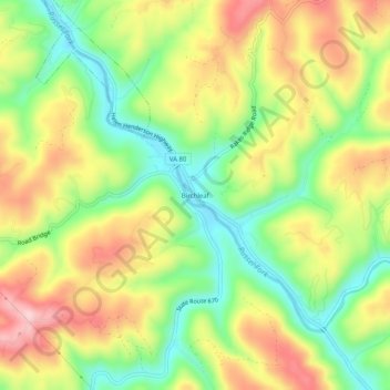
Name: Birchleaf topographic map, elevation, terrain.

Location: Birchleaf, Dickenson County, Virginia, 24220, United States (37.15733 -82.29209 37.19733 -82.25209)

Average elevation: 1,627 ft

Minimum elevation: 1,253 ft

Maximum elevation: 2,060 ft

Dickenson County trails, hiking, mountain biking, running and outdoor activities

Other topographic maps

Click on a map to view its topography, its elevation and its terrain.

Clinchco

United States > Virginia > Dickenson County

Average elevation: 1,742 ft

Russel Fork

United States > Virginia > Dickenson County > Haysi

Average elevation: 1,683 ft

Gear up for your next adventure:

🧷Carabiner Set - Durable clips for gear attachment
🦶Carbon Trekking Poles - Reduce knee impact on steep descents with ultra-light poles
🌄Hiking Binoculars - Compact binoculars for scenic views and trail spotting
🛡️Insect Repellent - Protection against bugs during outdoor activities
📚Navigation Handbooks - Master the art of reading topographic maps and using a compass

As an Amazon Associate, this site earns from qualifying purchases at no extra cost to you.