
Spokane topographic map
Click on the map to display elevation.
About this map
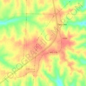
Name: Spokane topographic map, elevation, terrain.
Location: Spokane, Christian County, Missouri, United States (36.85146 -93.31583 36.87303 -93.29717)
Average elevation: 1,306 ft
Minimum elevation: 1,184 ft
Maximum elevation: 1,375 ft
Christian County trails, hiking, mountain biking, running and outdoor activities
Other topographic maps
Click on a map to view its topography, its elevation and its terrain.
Nixa
United States > Missouri > Christian County > Nixa
Nixa Public Schools operates four elementary schools for students in kindergarten through fourth grade: Helen-Matthews Elementary, Espy Elementary, Century Elementary, and the newest, High Pointe Elementary (named because it sits on the highest elevation in Christian County), opened in August 2007. Two…
Average elevation: 1,257 ft