Geolocate

Paquisha topographic map

Click on the map to display elevation.

About this map

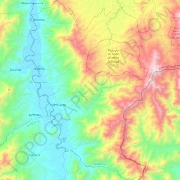
Name: Paquisha topographic map, elevation, terrain.

Location: Paquisha, Zamora Chinchipe, Ecuador (-4.07848 -78.69412 -3.84481 -78.47554)

Average elevation: 4,429 ft

Minimum elevation: 2,644 ft

Maximum elevation: 7,618 ft

Other topographic maps

Click on a map to view its topography, its elevation and its terrain.

Santa Elena

Ecuador > Zamora Chinchipe > Zamora > Zamora

Average elevation: 3,392 ft

El Líbano

Ecuador > Zamora Chinchipe > Zamora > Zamora

Average elevation: 5,148 ft

Gear up for your next adventure:

🦟Ultrasonic Repellers - Create a bug-free zone at your camp or rest stop
🌄Hiking Binoculars - Compact binoculars for scenic views and trail spotting
🎒Day Hiking Backpack - Lightweight backpack perfect for day trips and outdoor adventures
🔭Stargazing Telescopes - Perfect for camping in low-light pollution areas shown on maps
🧭Compass with Lanyard - Easy‑carry compass for navigation

As an Amazon Associate, this site earns from qualifying purchases at no extra cost to you.