
Make a donation
Gear up for your next adventure:
As an Amazon Associate, this site earns from qualifying purchases at no extra cost to you.
Denman Prospect topographic map
Click on the map to display elevation.
Make a donation
Gear up for your next adventure:
As an Amazon Associate, this site earns from qualifying purchases at no extra cost to you.
Denman Prospect
Denman Prospect is located to the north of Uriarra Road, west of John Gorton Drive and south of the Molonglo River. Topographically it is north east of Mount Stromlo with a series of valleys draining eastwards towards the Molonglo River in the south of the suburb, and the north east direction in the north. The highest points of the suburb are along hills on the eastern side at just over 654 metres high. Uriarra Road is about 630 m above sea level. The lowest point is on the Molonglo River just below 499 m above sea level. This makes Denman Prospect the lowest Canberra suburb.
Make a donation
Gear up for your next adventure:
As an Amazon Associate, this site earns from qualifying purchases at no extra cost to you.
About this map
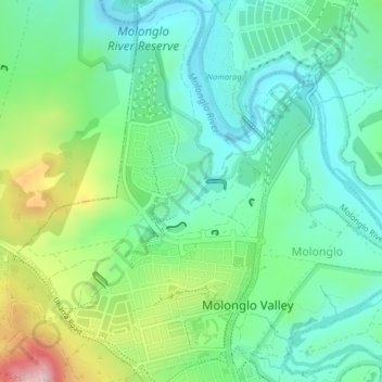
Name: Denman Prospect topographic map, elevation, terrain.
Average elevation: 1,880 ft
Minimum elevation: 1,634 ft
Maximum elevation: 2,470 ft
Make a donation
Gear up for your next adventure:
As an Amazon Associate, this site earns from qualifying purchases at no extra cost to you.