
Durmi topographic map
Click on the map to display elevation.
About this map
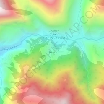
Name: Durmi topographic map, elevation, terrain.
Location: Durmi, Chamoli Tehsil, Chamoli, Uttarakhand, India (30.35139 79.49213 30.39139 79.53213)
Average elevation: 6,873 ft
Minimum elevation: 4,879 ft
Maximum elevation: 9,692 ft
Other topographic maps
Click on a map to view its topography, its elevation and its terrain.
Roopkund Lake
India > Uttarakhand > Chamoli Tehsil
Roopkund (locally known as Mystery Lake or Skeleton Lake) is a high altitude glacial lake in the Uttarakhand state of India. It lies in the lap of Trishul massif. Located in the Himalayas, the area around the lake is uninhabited and is roughly at an altitude of 5,020 metres (16,470 ft), surrounded by…
Average elevation: 15,194 ft