Geolocate

Galewela topographic map

Click on the map to display elevation.

About this map

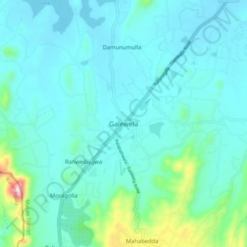
Name: Galewela topographic map, elevation, terrain.

Location: Galewela, Matale District, Central Province, Sri Lanka (7.71966 80.53110 7.79966 80.61110)

Average elevation: 794 ft

Minimum elevation: 587 ft

Maximum elevation: 2,028 ft

Other topographic maps

Click on a map to view its topography, its elevation and its terrain.

Upper Kotmale Dam

Sri Lanka > Central Province > Talawakele > Holyrood

Average elevation: 4,098 ft

Matale District

Sri Lanka > Central Province

Average elevation: 886 ft

Nuwara Eliya District

Sri Lanka > Central Province

Average elevation: 3,586 ft

Pitawala Pathana

Sri Lanka > Central Province

Average elevation: 2,421 ft

Canyon Dam

Sri Lanka > Central Province > Hapugastenne

Average elevation: 3,615 ft

Sigiriya

Sri Lanka > Central Province

Average elevation: 666 ft

Gear up for your next adventure:

🔦Powerful Headlamps - Ultra-bright hands-free lighting for night navigation
🧥Men's Rain Shells - Premium waterproof and breathable jackets for mountain weather
🎒Outdoor Daypacks - Lightweight backpacks designed for carrying maps and essential gear
🦟Ultrasonic Repellers - Create a bug-free zone at your camp or rest stop
🪶Trail Camera - Capture wildlife on your hikes

As an Amazon Associate, this site earns from qualifying purchases at no extra cost to you.