Geolocate

Fosio topographic map

Click on the map to display elevation.

About this map

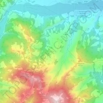
Name: Fosio topographic map, elevation, terrain.

Location: Fosio, Solignano, Parma, Emilia-Romagna, 43040, Italy (44.64586 9.98400 44.68586 10.02400)

Average elevation: 1,112 ft

Minimum elevation: 551 ft

Maximum elevation: 2,060 ft

Other topographic maps

Click on a map to view its topography, its elevation and its terrain.

Berceto

Italy > Emilia-Romagna > Parma

Average elevation: 2,516 ft

Albareto

Italy > Emilia-Romagna > Parma

Average elevation: 2,690 ft

Bore

Italy > Emilia-Romagna > Parma > Bore

Average elevation: 2,224 ft

Calestano

Italy > Emilia-Romagna > Parma > Calestano

Average elevation: 2,136 ft

Fornovo di Taro

Italy > Emilia-Romagna > Parma

Average elevation: 1,007 ft

Gear up for your next adventure:

🚪Portable Camp Chair - Foldable chair for comfort at camp
🎒Trail Energy Bars - High‑calorie bars for hiking energy
📚Navigation Handbooks - Master the art of reading topographic maps and using a compass
🧢Outdoor Hiking Hat - Sun protection hat for outdoor explorers
Backpacking Tents - Weight-optimized shelters for multi-day topographic surveys

As an Amazon Associate, this site earns from qualifying purchases at no extra cost to you.