
Make a donation
Gear up for your next adventure:
As an Amazon Associate, this site earns from qualifying purchases at no extra cost to you.
Moscow topographic map
Click on the map to display elevation.
Make a donation
Gear up for your next adventure:
As an Amazon Associate, this site earns from qualifying purchases at no extra cost to you.
About this map
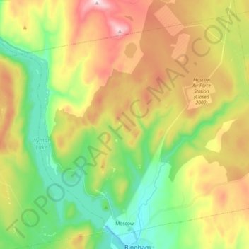
Name: Moscow topographic map, elevation, terrain.
Location: Moscow, Somerset County, Maine, 04920, United States (45.06474 -69.96659 45.17736 -69.78747)
Average elevation: 1,027 ft
Minimum elevation: 322 ft
Maximum elevation: 2,034 ft
Somerset County trails, hiking, mountain biking, running and outdoor activities
Make a donation
Gear up for your next adventure:
As an Amazon Associate, this site earns from qualifying purchases at no extra cost to you.
Other topographic maps
Click on a map to view its topography, its elevation and its terrain.
Jones Pond
United States > Maine > Somerset County > Bald Mountain Township T4 R3
Average elevation: 1,650 ft