
Thank you for supporting this site ❤️
Make a donation
Make a donation
Gear up for your next adventure:
As an Amazon Associate, this site earns from qualifying purchases at no extra cost to you.
Allalinhorn topographic map
Click on the map to display elevation.
Thank you for supporting this site ❤️
Make a donation
Make a donation
Gear up for your next adventure:
As an Amazon Associate, this site earns from qualifying purchases at no extra cost to you.
About this map
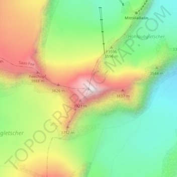
Name: Allalinhorn topographic map, elevation, terrain.
Location: Allalinhorn, Saas-Fee, Visp, Wallis, 3906, Schweiz (46.04604 7.89453 46.04614 7.89463)
Average elevation: 11,450 ft
Minimum elevation: 10,187 ft
Maximum elevation: 13,192 ft
Thank you for supporting this site ❤️
Make a donation
Make a donation
Gear up for your next adventure:
As an Amazon Associate, this site earns from qualifying purchases at no extra cost to you.
Other topographic maps
Click on a map to view its topography, its elevation and its terrain.