
Make a donation
Gear up for your next adventure:
As an Amazon Associate, this site earns from qualifying purchases at no extra cost to you.
Siguldas novads topographic map
Click on the map to display elevation.
Make a donation
Gear up for your next adventure:
As an Amazon Associate, this site earns from qualifying purchases at no extra cost to you.
About this map
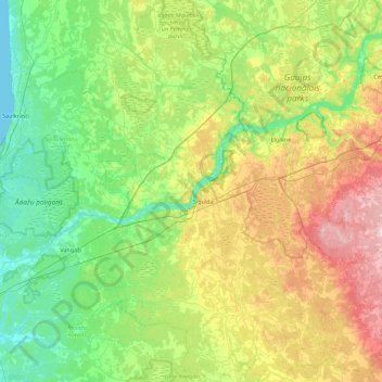
Name: Siguldas novads topographic map, elevation, terrain.
Location: Siguldas novads, Vidzeme, Latvia (56.92293 24.49841 57.41006 25.15707)
Average elevation: 226 ft
Minimum elevation: 0 ft
Maximum elevation: 748 ft
Make a donation
Gear up for your next adventure:
As an Amazon Associate, this site earns from qualifying purchases at no extra cost to you.
Other topographic maps
Click on a map to view its topography, its elevation and its terrain.
Make a donation
Gear up for your next adventure:
As an Amazon Associate, this site earns from qualifying purchases at no extra cost to you.
Bormaņi
Latvia > Vidzeme > Smiltenes novads > Raunas pagasts > Cimza > Bormaņi
Average elevation: 456 ft