
Thank you for supporting this site ❤️
Make a donation
Make a donation
Gear up for your next adventure:
As an Amazon Associate, this site earns from qualifying purchases at no extra cost to you.
Safsaf topographic map
Click on the map to display elevation.
Thank you for supporting this site ❤️
Make a donation
Make a donation
Gear up for your next adventure:
As an Amazon Associate, this site earns from qualifying purchases at no extra cost to you.
About this map
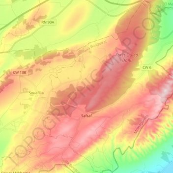
Name: Safsaf topographic map, elevation, terrain.
Location: Safsaf, daïra Bouguirat, Mostaganem, Algérie (35.80067 0.33748 35.93131 0.47113)
Average elevation: 948 ft
Minimum elevation: 154 ft
Maximum elevation: 1,699 ft
Thank you for supporting this site ❤️
Make a donation
Make a donation
Gear up for your next adventure:
As an Amazon Associate, this site earns from qualifying purchases at no extra cost to you.