
Thank you for supporting this site ❤️
Make a donation
Make a donation
Gear up for your next adventure:
As an Amazon Associate, this site earns from qualifying purchases at no extra cost to you.
Taosi topographic map
Click on the map to display elevation.
Thank you for supporting this site ❤️
Make a donation
Make a donation
Gear up for your next adventure:
As an Amazon Associate, this site earns from qualifying purchases at no extra cost to you.
About this map
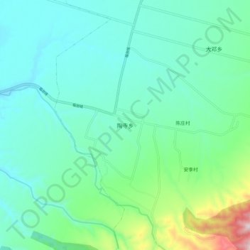
Name: Taosi topographic map, elevation, terrain.
Location: Taosi, Xiangfen County, Linfen City, Shanxi, 041500, China (35.85696 111.45875 35.93696 111.53875)
Average elevation: 1,798 ft
Minimum elevation: 1,388 ft
Maximum elevation: 3,419 ft
Thank you for supporting this site ❤️
Make a donation
Make a donation
Gear up for your next adventure:
As an Amazon Associate, this site earns from qualifying purchases at no extra cost to you.