Geolocate

Monticello topographic map

Click on the map to display elevation.

About this map

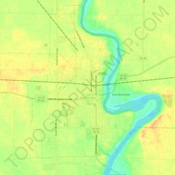
Name: Monticello topographic map, elevation, terrain.

Location: Monticello, White County, Indiana, United States (40.72541 -86.78978 40.77050 -86.74036)

Average elevation: 679 ft

Minimum elevation: 604 ft

Maximum elevation: 732 ft

White County trails, hiking, mountain biking, running and outdoor activities

Other topographic maps

Click on a map to view its topography, its elevation and its terrain.

Sitka

United States > Indiana > White County

Average elevation: 679 ft

Idaville

United States > Indiana > White County

Average elevation: 699 ft

Isle of Homes

United States > Indiana > White County

Average elevation: 699 ft

Gear up for your next adventure:

🔭Compact Binoculars - HD vision for scouting terrain and identifying distant landmarks
❄️Traction Cleats - Prevent slips on icy trails during winter hikes
🪄Magnetic Compass - Accurate compass for navigation
💧Water Filtration Bottles - Safely drink from streams and lakes while exploring
🥘Titanium Cookware - Durable, featherlight pots and pans for backpacking

As an Amazon Associate, this site earns from qualifying purchases at no extra cost to you.