
Make a donation
Gear up for your next adventure:
As an Amazon Associate, this site earns from qualifying purchases at no extra cost to you.
Kenz-Küstrow topographic map
Click on the map to display elevation.
Make a donation
Gear up for your next adventure:
As an Amazon Associate, this site earns from qualifying purchases at no extra cost to you.
Kenz-Küstrow
Kenz-Küstrow liegt etwa vier Kilometer südlich von Barth. Der Nordosten der Gemeinde grenzt an den Grabow, eines Teils der Darß-Zingster Boddenkette. Die Boddenküste ist vor allem im Süden flach und sumpfig. Hier mündet der Zipker Bach in den Bodden, welcher auch die Südgrenze der Gemeinde bildet. Die Geländehöhen steigen dann in einen in Nord-Süd-Richtung verlaufenden Höhenzug bei Küstrow und Rubitz auf über dreißig Meter an. Im Norden reicht der Höhenzug fast bis zur Boddenküste.
Make a donation
Gear up for your next adventure:
As an Amazon Associate, this site earns from qualifying purchases at no extra cost to you.
About this map
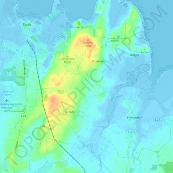
Name: Kenz-Küstrow topographic map, elevation, terrain.
Average elevation: 16 ft
Minimum elevation: -23 ft
Maximum elevation: 102 ft
Make a donation
Gear up for your next adventure:
As an Amazon Associate, this site earns from qualifying purchases at no extra cost to you.