
Guriezo topographic map
Interactive map
Click on the map to display elevation.
Guriezo
La altitud oscila entre los 748 metros al sureste (pico Betayo), en el límite con Castro-Urdiales y Arcentales, y el nivel del mar cerca de la desembocadura del Agüera. La capital municipal se alza a 23 metros sobre el nivel del mar.
About this map
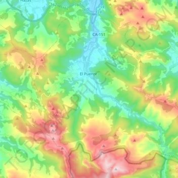
Name: Guriezo topographic map, elevation, terrain.
Location: Guriezo, Asón-Agüera, Cantabria, 39788, España (43.28610 -3.37347 43.38781 -3.21743)
Average elevation: 978 ft
Minimum elevation: -7 ft
Maximum elevation: 2,690 ft