
Oak Ridge topographic map
Click on the map to display elevation.
About this map
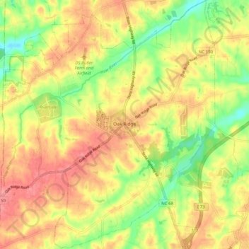
Name: Oak Ridge topographic map, elevation, terrain.
Average elevation: 886 ft
Minimum elevation: 745 ft
Maximum elevation: 997 ft
Guilford County trails, hiking, mountain biking, running and outdoor activities
Other topographic maps
Click on a map to view its topography, its elevation and its terrain.
Hamilton Lakes
United States > North Carolina > Guilford County > Greensboro
Average elevation: 866 ft
Piedmont Heights
United States > North Carolina > Guilford County > Greensboro
Average elevation: 823 ft
Sherwood Village
United States > North Carolina > Guilford County > High Point
Average elevation: 860 ft
Hamilton Hills
United States > North Carolina > Guilford County > Greensboro
Average elevation: 899 ft
Melborne Heights
United States > North Carolina > Guilford County > High Point
Average elevation: 840 ft
Horsepen Creek
United States > North Carolina > Guilford County > Greensboro
Average elevation: 817 ft