Geolocate

Julian topographic map

Click on the map to display elevation.

About this map

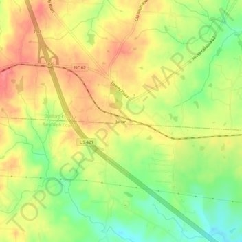
Name: Julian topographic map, elevation, terrain.

Location: Julian, Guilford County, North Carolina, 27283, United States (35.88514 -79.68030 35.92514 -79.64030)

Average elevation: 738 ft

Minimum elevation: 617 ft

Maximum elevation: 837 ft

Guilford County trails, hiking, mountain biking, running and outdoor activities

Other topographic maps

Click on a map to view its topography, its elevation and its terrain.

Greensboro

United States > North Carolina > Guilford County

Greensboro is characterized by a gently rolling topography, typical of the Piedmont region. The city sits at an elevation of approximately 790 feet (241 meters) above sea level, with its terrain featuring a mix of low hills and valleys that create a varied landscape. The area is bisected by several waterways,…

Average elevation: 794 ft

Oak Ridge

United States > North Carolina > Guilford County

Average elevation: 886 ft

Oak Ridge

United States > North Carolina > Guilford County

Average elevation: 886 ft

Jamestown

United States > North Carolina > Guilford County

Average elevation: 814 ft

Oak Ridge

United States > North Carolina > Guilford County

Average elevation: 886 ft

Whitsett

United States > North Carolina > Guilford County

Average elevation: 669 ft

Gear up for your next adventure:

🧭Orienteering Set - Complete compass and map reading kit
🦺Reflective Outdoor Gear - Safety gear for low‑light conditions
🧭Map Reading Tools - Tools and kits for map navigation
🚪Portable Camp Chair - Foldable chair for comfort at camp
📦Gear Storage Bags - Organize and protect outdoor equipment

As an Amazon Associate, this site earns from qualifying purchases at no extra cost to you.