Geolocate

Gisagara topographic map

Click on the map to display elevation.

About this map
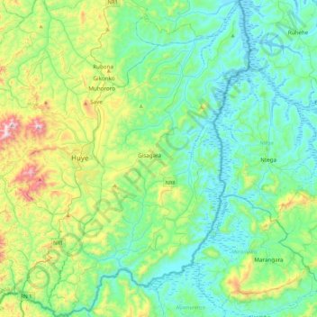
Name: Gisagara topographic map, elevation, terrain.

Location: Gisagara, Southern Province, Rwanda (-2.81969 29.69788 -2.39428 29.96995)

Average elevation: 5,108 ft

Minimum elevation: 4,423 ft

Maximum elevation: 7,474 ft

Other topographic maps

Click on a map to view its topography, its elevation and its terrain.

Kabgayi

Rwanda > Southern Province > Muhanga District > Nyamabuye

Kabgayi lies in the middle of Rwanda's central plateau at an elevation of about 6,000 feet (1,800 m) above sea level. Located in Kamazuru Village of Gahogo Cell in Nyamabuye Sector, it is a 5 minutes’ drive from Muhanga City. The community is just south of Gitarama, the second-largest city in Rwanda, and…

Average elevation: 6,020 ft

Kigeme

Rwanda > Southern Province > Nyamagabe > Gasaka

Average elevation: 6,696 ft

Muhuroro

Rwanda > Southern Province > Ruhango > Byimana

Average elevation: 5,942 ft

Agatare

Rwanda > Southern Province > Gisagara > Gishubi

Average elevation: 4,652 ft

Muhanga

Rwanda > Southern Province > Muhanga District

Average elevation: 5,522 ft

Rubyiro

Rwanda > Southern Province > Nyamagabe > Buruhukiro

Average elevation: 7,917 ft

Masango

Rwanda > Southern Province > Ruhango > Kinihira

Average elevation: 5,558 ft

Rubona

Rwanda > Southern Province > Huye > Rusatira

Average elevation: 5,364 ft

Gear up for your next adventure:

🔭Compact Binoculars - HD vision for scouting terrain and identifying distant landmarks
🚑Emergency Bivvies - Heat-reflective sleeping bags for survival situations
🥾Men's Hiking Boots - Durable, waterproof footwear for rugged terrain and steep inclines
📱Solar Portable Charger - Solar power bank for charging devices off‑grid
🛠️Outdoor Gear Repair Kit - Essential tools to fix gear on the trail

As an Amazon Associate, this site earns from qualifying purchases at no extra cost to you.