
Make a donation
Gear up for your next adventure:
As an Amazon Associate, this site earns from qualifying purchases at no extra cost to you.
Bone Cave topographic map
Click on the map to display elevation.
Make a donation
Gear up for your next adventure:
As an Amazon Associate, this site earns from qualifying purchases at no extra cost to you.
About this map
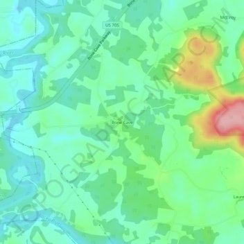
Name: Bone Cave topographic map, elevation, terrain.
Average elevation: 925 ft
Minimum elevation: 794 ft
Maximum elevation: 1,283 ft
Van Buren County trails, hiking, mountain biking, running and outdoor activities
Make a donation
Gear up for your next adventure:
As an Amazon Associate, this site earns from qualifying purchases at no extra cost to you.
Other topographic maps
Click on a map to view its topography, its elevation and its terrain.
Spencer
United States > Tennessee > Van Buren County
Spencer is topographically isolated by the Cumberland Plateau's escarpment to the north and west, the Cane Creek Valley to the east, and the Dry Fork Gulf to the south. Cane Creek, along with its tributary, Dry Fork, slices a narrow valley as it spills down northward toward its confluence with the Caney Fork,…
Average elevation: 1,627 ft