
Thank you for supporting this site ❤️
Make a donation
Make a donation
Gear up for your next adventure:
As an Amazon Associate, this site earns from qualifying purchases at no extra cost to you.
Reyðarfjörður topographic map
Click on the map to display elevation.
Thank you for supporting this site ❤️
Make a donation
Make a donation
Gear up for your next adventure:
As an Amazon Associate, this site earns from qualifying purchases at no extra cost to you.
About this map
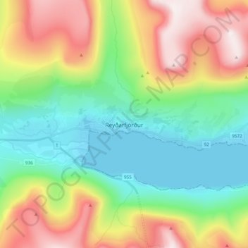
Name: Reyðarfjörður topographic map, elevation, terrain.
Location: Reyðarfjörður, Fjarðabyggð, Austurland, 731, Island (64.99407 -14.24847 65.07407 -14.16847)
Average elevation: 1,168 ft
Minimum elevation: 0 ft
Maximum elevation: 3,202 ft
Thank you for supporting this site ❤️
Make a donation
Make a donation
Gear up for your next adventure:
As an Amazon Associate, this site earns from qualifying purchases at no extra cost to you.