
Make a donation
Gear up for your next adventure:
As an Amazon Associate, this site earns from qualifying purchases at no extra cost to you.
Vrank topographic map
Click on the map to display elevation.
Make a donation
Gear up for your next adventure:
As an Amazon Associate, this site earns from qualifying purchases at no extra cost to you.
About this map
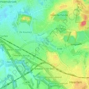
Name: Vrank topographic map, elevation, terrain.
Location: Vrank, Heerlen, Limburg, Nederland, 6412 PG, Nederland (50.88458 5.93509 50.92458 5.97509)
Average elevation: 312 ft
Minimum elevation: 240 ft
Maximum elevation: 449 ft
Make a donation
Gear up for your next adventure:
As an Amazon Associate, this site earns from qualifying purchases at no extra cost to you.
Other topographic maps
Click on a map to view its topography, its elevation and its terrain.
Brunssummerheide
De Schrieversheide (op Heerlens grondgebied) is een restant van een groter heideveld dat deels bebost is geraakt, verdwenen onder een vuilstort of bebouwd. Het werd na de Tweede Wereldoorlog gebruikt als militair oefenterrein. De als waardevol en fraai omschreven Schrieversheide is een van de meer…
Average elevation: 344 ft