Geolocate

Sims topographic map

Click on the map to display elevation.

About this map

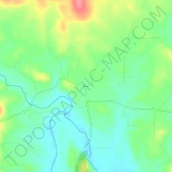
Name: Sims topographic map, elevation, terrain.

Location: Sims, Montgomery County, Arkansas, 71969, United States (34.63926 -93.71103 34.67926 -93.67103)

Average elevation: 745 ft

Minimum elevation: 646 ft

Maximum elevation: 935 ft

Montgomery County trails, hiking, mountain biking, running and outdoor activities

Other topographic maps

Click on a map to view its topography, its elevation and its terrain.

Oden

United States > Arkansas > Montgomery County

Average elevation: 768 ft

Black Springs

United States > Arkansas > Montgomery County

Average elevation: 748 ft

Mount Ida

United States > Arkansas > Montgomery County > Mount Ida

Average elevation: 705 ft

Norman

United States > Arkansas > Montgomery County

Average elevation: 745 ft

Gear up for your next adventure:

🏕️Family Camping Gear - Essentials for group camping trips
🎁Geography Themed Gifts - Unique gift ideas for map lovers and geography enthusiasts
🪶Multi‑Purpose Knife - Useful blade for camp and trail
🪓Survival Multi‑Tool - Versatile tool for camp and trail tasks
🪶LED Camping Lantern - Bright lantern for camp lighting

As an Amazon Associate, this site earns from qualifying purchases at no extra cost to you.