Geolocate

Beauty Point topographic map

Click on the map to display elevation.

About this map

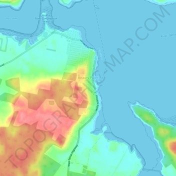
Name: Beauty Point topographic map, elevation, terrain.

Location: Beauty Point, West Tamar, Tasmania, Australia (-41.17790 146.77016 -41.14058 146.82664)

Average elevation: 66 ft

Minimum elevation: -7 ft

Maximum elevation: 259 ft

Other topographic maps

Click on a map to view its topography, its elevation and its terrain.

Cathedral Mountain

Australia > Tasmania

Average elevation: 3,255 ft

Waterworks Reserve

Australia > Tasmania > Hobart

Average elevation: 787 ft

Rowlands Hill

Australia > Tasmania

Average elevation: 1,273 ft

Cradle Mountain

Australia > Tasmania > Cradle Mountain

Average elevation: 3,753 ft

The Nut

Australia > Tasmania > Stanley

Average elevation: 26 ft

Bream Creek

Australia > Tasmania > Bream Creek

Average elevation: 115 ft

Buxton Point

Australia > Tasmania > Little Swanport

Average elevation: 10 ft

Mount Patrick

Australia > Tasmania

Average elevation: 2,831 ft

Mount Ossa

Australia > Tasmania

Average elevation: 3,996 ft

West Gawler River

Australia > Tasmania > Sprent > Gawler

Average elevation: 659 ft

Mount Tyndall

Australia > Tasmania

Average elevation: 2,986 ft

Gear up for your next adventure:

🔌USB Car Charger - Car charger for on‑the‑go power needs
🔌Solar Panel Charger - Charge gear sustainably outdoors
🪶Thermal Camp Blanket - Extra warmth for cold nights
🪓Survival Multi‑Tool - Versatile tool for camp and trail tasks
🥩Freeze-Dried Meals - Nutritious and lightweight food for remote expeditions

As an Amazon Associate, this site earns from qualifying purchases at no extra cost to you.