
Milton topographic map
Click on the map to display elevation.
About this map
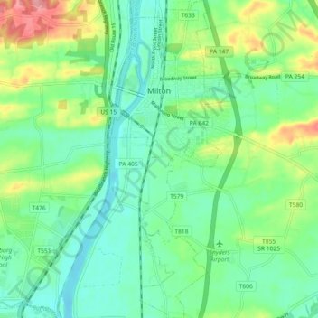
Name: Milton topographic map, elevation, terrain.
Average elevation: 515 ft
Minimum elevation: 413 ft
Maximum elevation: 745 ft
Northumberland County trails, hiking, mountain biking, running and outdoor activities
Other topographic maps
Click on a map to view its topography, its elevation and its terrain.
Bear Gap
United States > Pennsylvania > Northumberland County > Ralpho Township > Bear Gap
Average elevation: 1,040 ft
Fishers Ferry
United States > Pennsylvania > Northumberland County > Fishers Ferry
Average elevation: 551 ft
Overlook
United States > Pennsylvania > Northumberland County > Ralpho Township
Average elevation: 856 ft