
Make a donation
Gear up for your next adventure:
As an Amazon Associate, this site earns from qualifying purchases at no extra cost to you.
Langdorp topographic map
Click on the map to display elevation.
Make a donation
Gear up for your next adventure:
As an Amazon Associate, this site earns from qualifying purchases at no extra cost to you.
Langdorp
Langdorp ligt op de grens van de Zuiderkempen en het Hageland. Ten zuiden van Langdorp stroomt de Demer. Ook loopt er de Laak. Ten noorden van Langdorp ligt een bosgebied. Hier ligt een reeks getuigenheuvels met kernen van ijzerzandsteen.De hoogte daarvan loopt op tot 48 meter.
Make a donation
Gear up for your next adventure:
As an Amazon Associate, this site earns from qualifying purchases at no extra cost to you.
About this map
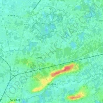
Name: Langdorp topographic map, elevation, terrain.
Average elevation: 56 ft
Minimum elevation: 20 ft
Maximum elevation: 187 ft
Make a donation
Gear up for your next adventure:
As an Amazon Associate, this site earns from qualifying purchases at no extra cost to you.
Other topographic maps
Click on a map to view its topography, its elevation and its terrain.